 |
| The longest river in the world, the Nile flows 4,187 miles from south to north and empties into the Mediterranean Sea. That's longer than the distance across the U.S. from coast to coast! In addition to providing fertile soil for agriculture along its banks, the Nile served as a major "highway" through Egypt for ships carrying goods from one city to another. The Nile served the ancient Egyptians as an important resource for food and trade. |
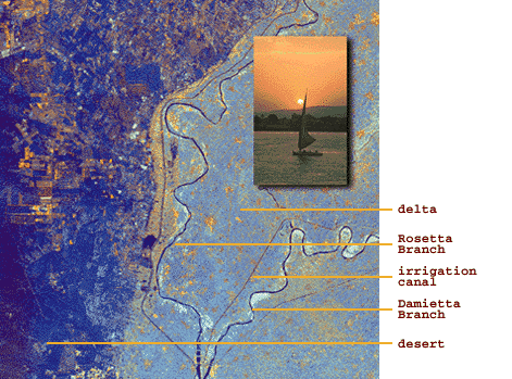 |
| This radar image of the Nile was taken by the space shuttle Endeavour. We are looking at the area just north of the city of Cairo, Egypt, where the Nile River splits into two main branches. The Rosetta Branch is the curving dark line in the center of the image and the Damietta Branch is the curving dark line in the lower right of the image. The light blue area on the right half of the image is a portion of the Nile River delta, the desert is the dark blue area on the left side. The thinner, straighter lines and the small network of gold lines are irrigation canals. There are more than 10,000 kilometers of canals throughout the Nile delta. |
 |
 |
 |
 |
 |
 |
© Michael C. Carlos Museum of Emory University,
Memorial Art Gallery of the University of Rochester and Dallas Museum of Art
For more information please contact odyssey@emory.edu.
Last Update: