 |
|
|
Look at this map and notice where the cities in ancient Egypt were located. Ancient Egyptian civilization developed in the delta and valley regions of the Nile River, isolated and protected by vast deserts on either side. The Nile River was the "backbone" of Egypt. The annual flooding of the river deposited rich soil allowing farmers to raise crops along the river banks. This fertile strip along the Nile was never more than 12 miles wide. Rich agricultural and mineral resources along with protection provided by the desert allowed a long-lasting civilization to develop in Egypt. |
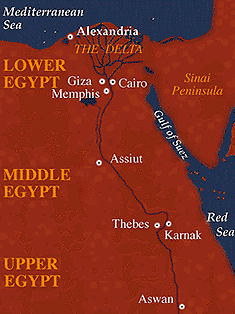
| Here is a list of some of the places on this map. Click on them for pronunciation: |
|
|
 |
 |
 |
 |
 |
 |
© Michael C. Carlos Museum of Emory University,
Memorial Art Gallery of the University of Rochester and Dallas Museum of Art
For more information please contact odyssey@emory.edu.
Last Update: